
Introduction
Exeter Airport , (ICAO: EGTE, IATA: EXT) which began operating in 1937, is a UK Certified Aerodrome in accordance with EU 139/2014.
Runway 08/26
ICAO: EGTE – IATA: EXT | Runway Length: 2076 metres x 45 metres (asphalt) | Runway Approach Bars: 08/26 with runway lights | Aerodrome Elevation: 100ft | Navigational Aids: ILS Radar, DRDF, NDB, DME (36x) | Coordinates: 50° 44′ 4″ N, 3° 24′ 50″ W
Pilot Briefing (GA)
General Aviation (GA) Pilot Briefing is situated at Aviation South West.
Telephone: 01392 354 915
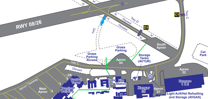
Pilots and passengers are to use appropriate walkways (shown in green on the plan), between aircraft parking areas and landside. A footpath runs from the western edge of the South Apron, across Apron 24 and taxiway Charlie to the access control point. Under no circumstances are flightcrew or passengers to walk along any portion of taxiway Charlie. Pedestrians must remain aware to the risk of live aircraft at all times and ensure that taxiway Charlie is clear before crossing.’
The NATS Aeronautical Information Service website posts notices relating to safety, navigation, technical, administrative and legal matters. eg:
- Exeter Aerodrome – Textual Data
- Aerodrome Chart
- Aircraft Parking/Docking Chart
- ATC Surveillance Minimum Altitude Chart
UK Border Force GAR requirement
An operator or pilot of a general aviation aircraft is required to report international or Channel Islands journeys to or from the UK, unless they are travelling outbound directly from the UK.
The General Aviation Report (GAR) submitted online will be distributed to Border Force and the Police to facilitate the smooth passage of legitimate persons and goods across the border and prevent crime and terrorism in the Common Travel Area.
The aircraft commander has a legal responsibility for all persons and goods carried.
Aircraft Parking
Fixed wing aircraft with a MTOW of 1500kg – 1799kg requiring any duration of parking on airport operated aprons or grass areas and/or for Jet A1 fuel are subject to prior permission (PPR).
Non based aircraft with a MTOW of 1800kg or higher are subject to mandatory handling when parking is required, excluding aircraft visiting formal maintenance facilities.
The operator is to request PPR or mandatory handling via XLR Exeter Executive Jet Centre via Email: [email protected] – Telephone: 01392 354995
Private Operator Opening Hours (local)
Summer (BST) Mon – Fri 0800 – 2000 Sat 0800 – 1900 Sun 0900 – 2000
Winter (GMT) Mon-Fri: 08.00-18.00 | Sat – Sun: 09.00-17.00
Please see Managing the Impact of Aircraft Noise and other items on the Environmental page.
Airfield Users
Based pilots should also be aware of the information within Exeter Airport’s Aerodrome Manual and Important Airfield Information (IAI) posted on Airfield Users Information (Based Users Only).
Refuelling
Exeter Airport will supply AVTUR and AVGAS fuel.
Fuel availability
Summer (BST)
Jet A1 available as per Private Operator Opening Hours
Avgas Mon – Fri 0800 – 1900 Sat 0800 -1800 Sun 0900 – 1900
Winter
Jet A1 and Avgas available as per Private Operator Opening Hours
Air Traffic Control
Radar provides primary and secondary movement data. Aircraft on the Approach & Departure paths and aircraft flying on Circuits are monitored. Lower Airspace Radar Services (LARS) are also provided to overflying aircraft on behalf of the Civil Aviation Authority. The Visual Control Room oversees airfield movements.
Airfield Services
Aircraft marshalling, baggage handling, steps, ambulift, push-back services, aircraft cleaning and catering services is coordinated by Airfield Services. Noise related incidents are monitored and answers to frequently asked questions can be found in the Environmental section.
Airport Fire Service
The fire department is CAA certified provides a service to Category 6 with upgrades of above on request.
Aerodrome Safeguarding
Safeguarding is the process by which the Aerodrome Operator can protect the environment surrounding the Aerodrome from developments that have the potential to impact on the aerodrome’s safe operation. Aerodrome safeguarding covers several aspects. Its purpose is to protect:
- the airspace around an aerodrome to ensure no buildings or structures may cause danger to aircraft either in the air or on the ground. This is achieved through both the ‘Obstacle Limitation Surfaces’ (OLS) and the ‘Instrument Flight Procedure’ (IFP).
- the integrity of radar and other electronic aids to navigation by preventing reflections and diffractions of the radio signals.
- aeronautical lighting, such as approach and runway lighting, by ensuring that they are not obscured by any proposed development and that any proposed lighting, either temporary or permanent, could not be confused for aeronautical ground lighting.
- the aerodrome from any increased wildlife strike risk. In particular bird strikes, which can pose a serious threat to flight safety.
- aerodrome operations from interference by any construction processes through the production of dust/smoke, temporary lighting or construction equipment impacting on radar and other navigational aids.
- aircraft from the risk of collision with obstacles through the appropriate use of lighting.
- aircraft from the risk of building induced turbulence.
- aircraft from the risk from glint and glare, e.g solar panels.
Drones
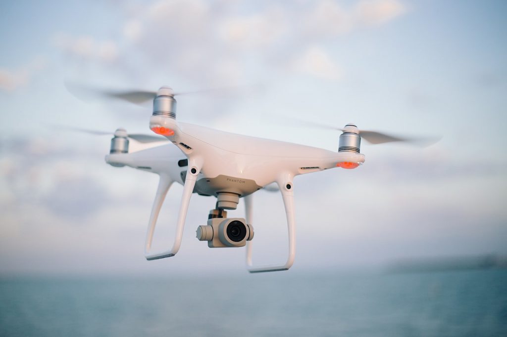
It is illegal to fly any drone at any time within restricted zones
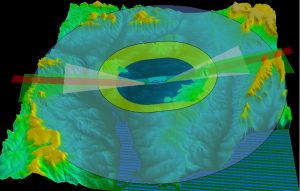
The flying restriction area uses the airfield’s existing aerodrome traffic zone, which has a radius of two and a half nautical miles and then 5km (3.1miles) by 1km (0.62miles) zones starting from the point known as the ‘threshold’ at the end of each of the airfields runways. Both zones extend upwards to a height of 2,000 feet above the airfield. This restriction replaces the 1km from the airfield boundary rule.
The restriction applies for the area highlighted in the Flight Restricted Zone (FRZ) map for Exeter Airport.
A drone (also called UAV/UAS) flown in the UK is the responsibility of the owner who should be aware of the rules and restrictions. For more information visit Drones and new airspace users – NATS
It is illegal to fly any drone at any time within these restricted zones unless permission is granted by Air Traffic Control at the airport. For permission, email details of location, date and height of intended operation to [email protected]
Cranes / Tall Equipment
As with any tall object, the presence of a single crane or number of cranes has the potential to affect aviation activities. In the main, crane-related issues are considered and managed in much the same way as for any tall object, however due to the distinctive character of the crane construction and operations, they are addressed separately.
All Crane users must follow the guidance and notification process as detailed in Civil Aviation Authority CAP1096 Guidance to crane users on the crane notification process and obstacle lighting and marking
The guidance should be considered relevant to users of all cranes within 10nm (18.5km) of the aerodrome and exceeding a height of 10 m above ground level (AGL) or that of the surrounding structures or trees (if higher).
The operation of cranes could present a serious hazard to air navigation, particularly during the approach and departure phases of flight when aircraft are at low altitudes. In addition to the creation of an obstacle, cranes could also interfere with navigation and/or communication equipment. Implications to flight safety may be mitigated by coordinating crane and aircraft operations through the advance notification of the crane to the CAA. The CAA will in turn process and share the crane notification with relevant parties which require this information.
Tall Equipment permit charges apply see Fees and Charges
For further information and guidance email [email protected]
Wind Turbines
Wind turbines can pose a physical infringement on flight surfaces. They can cause problems with aircraft navigation aids, air traffic control radars, and can cause turbulence. Exeter Airport is responsible for assessing any proposed wind turbine sites within 60km of the aerodrome, to ensure safety for aircraft is maintained.
The Local Planning Authority (LPA) will forward any wind turbine applications within the aforementioned area to the airport for assessment. The airport’s Safeguarding officer will assess the physical and technical impact of a proposed development.
Landscaping and Wildlife
Aircraft are vulnerable to bird strikes. 80% of bird strikes occur on or close to aerodromes, therefore highlighting the necessity for wildlife management on and within the proximity of an airfield. Exeter Airport is responsible for monitoring bird activity within a 13km radius of the aerodrome. This is to mitigate the bird strike risk to aircraft and be aware of what species we have in the local area. The objective of the safeguarding process is to prevent any increase in, and where possible reduce the bird strike risk at the aerodrome.
Any proposed developments, which are looking to include landscaping, or water features which may increase the risk of bird strike to aircraft must be forwarded to the Safeguarding Officer for assessment. This includes landfill sites, wetlands and nature reserves.
Pre-Planning Applications
Exeter Airport welcomes pre-planning application discussions on wind farm, photovoltaic / solar array and any other developments or issues that might have an impact on aerodrome safety / operations. Examples of such items are not exhaustive but could include lighting, creation of potential bird hazards, cranes / tall equipment and other construction issues within the vicinity of or the safeguarded areas for the aerodrome.
Charges may apply for providing analysis and Safeguarding information. See Fees and Charges
For more information please email [email protected]
Airport Operators Association advice notes
Advice Note 1 Aerodrome Safeguarding an Overview
Advice Note 3 Wildlife Hazards
Advice Note 5 Renewable Energy
Operation of Directed Light, Fireworks, Toy Balloons and Sky Lanterns
The CAA’s CAP 736 Operation of Directed Light, Fireworks, Toy Balloons and Sky Lanterns within UK Airspace is published to provide policy and supporting guidance for commercial organisations and individuals planning to operate directed light, fireworks, toy balloons and sky lanterns in UK airspace. Information on notification procedures and CAA application forms are contained within the document; provided event information will enable the aviation community to properly assess the impact of any such proposed activity and take appropriate measures to mitigate any dangers to flight safety. Please notify the CAA using DAP1918 Form
CAST
– Combined Aerodrome Safeguarding Team
Further
Aerodrome Safeguarding information, Publications and FAQs can be found on the
Civil Aviation Authority website via the following link.